YOUR NEXT DISCOVERY/SpaceFollow your curiosity
Digital Elevation Map of Spirit Trek
NASA / JPL · Reuse terms

Space / 2004-12-08

Digital Elevation Map of Spirit Trek

Digital Elevation Map of Spirit Trek

NASA's image library records Digital Elevation Map of Spirit Trek.

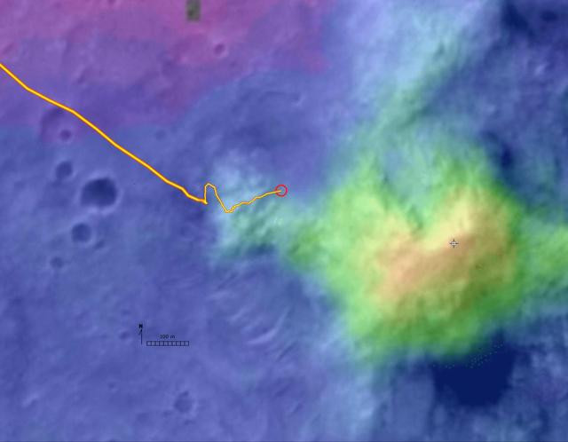
This digital elevation map, produced from satellite data overlain on an image taken by the Mars Orbital Camera on NASA's Mars Global Surveyor spacecraft, shows changes in elevation along the trek of NASA's Mars Exploration Rover Spirit as of the rover's 328th martian day, or sol (Dec. 4, 2004). To that point, Spirit had driven a total of 3.89 kilom

SERENDIPITYA little unexpected
FamiliarWeird

This digital elevation map, produced from satellite data overlain on an image taken by the Mars Orbital Camera on NASA's Mars Global Surveyor spacecraft, shows changes in elevation along the trek of NASA's Mars Exploration Rover Spirit as of the rover's 328th martian day, or sol (Dec. 4, 2004). To that point, Spirit had driven a total of 3.89 kilometers (2.42 miles). The blue area represents the basaltic plains on the floor of Gusev Crater, about 20 meters (66 feet) below the rover's present location. Spirit crossed those plains for several months after landing to the west, off the left edge of this image. The greenish-blue area is the "West Spur" of the "Columbia Hills," which Spirit reached on sol 156 (June 11, 2004). Since then, Spirit has been gradually ascending the slopes of the "Wes

Explore NASA's original image record for credits and available downloads.

NASA Image and Video LibraryDigital Elevation Map of Spirit Trek

Original explanation based on the sources above. Images carry their own reuse terms.